In order to use this website you need to accept the use of Cookies , our Privacy Policy , and our Terms and Conditions.
Garmin BlueChart g3 Vision HD Micro SD Card - Knysna, SA to Beira, MZ, VAF452S
R5,509.00
SKU
010C075200
Helps you to chart from South Africa to Beira, Knysna & Mozambique's marine area Garmin Auto Guidance technology Depth Range Shading for up to 10 depth ranges Up to 1-foot contours provide a more accurate depiction Keep your charts up to date


Description
The Garmin BlueChart g3 Vision HD Micro SD Card features Auto Guidance technology quickly calculates a suggested route using your boat's dimensions and a suggested path to follow. Displays high-resolution Depth Range Shading for up to 10 depth ranges, so you can view your designated target depth. BlueChart g3 Vision HD features detailed 1-foot contours that provide a more accurate depiction of bottom structure for improved fishing charts and enhanced detail in swamps, canals and port plans.
MarinerEye View, provides a 3-D representation of the ocean floor as seen from below the waterline. FishEye View, provides a 3-D representation of the surrounding area, both above and below the waterline. High-resolution satellite imagery with navigational charts overlaid gives you a realistic view of your surroundings, so you can navigate with a clear moving-chart representation of your boat's position. It's our most realistic charting display in a chartplotter.
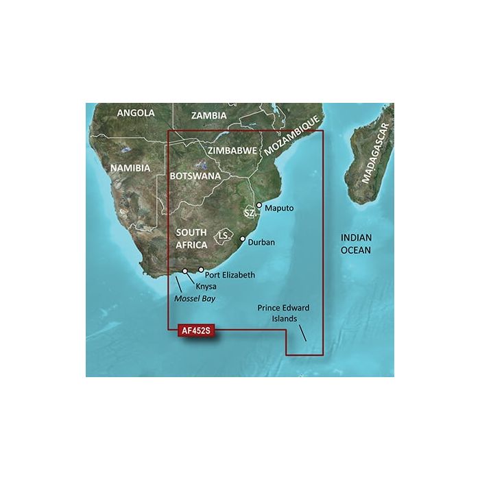
Crystal clear aerial photography shows exceptional detail of many ports, harbours and marinas and is ideal when entering unfamiliar ports. Provides coverage of the southeastern coast of Africa from Mossel Bay, S. Af. to the mouth of the Zambezi River. Detailed coverage includes Port Elizabeth and Durban, S. Af., Maputo, Moz., as well as the Prince Edward Islands.
Features
- Derived from official charts and private sources to provide navigational aids, spot soundings, depth contours, tides and currents, and detailed harbours and marinas
- Garmin Auto Guidance technology shows a suggested route to a destination
- Depth Range Shading for up to 10 depth ranges enables you to view your target depth at a glance
- Up to 1-foot contours provide a more accurate depiction of the bottom structure for improved fishing charts and navigation
- Shallow Water Shading feature allows for depth shading at a user-defined level to aid in navigation
- Unique 3D views like MarinerEye and FishEye provide additional perspective both above and below the water line
- High-resolution satellite imagery of ports, marinas, bridges and navigational landmarks for superior situational awareness
- Keep your charts up to date with our industry-leading New Chart Guarantee and discount card update program
- Worldwide coverage available
Specifications
| Brand | Garmin |
| Card | SD card |
| Map Charts | Africa, Knysna, SA to Beira, MZ Coastal and Inland |
| Free Shipping | No |
|---|
Write Your Own Review
Customer Questions