In order to use this website you need to accept the use of Cookies , our Privacy Policy , and our Terms and Conditions.
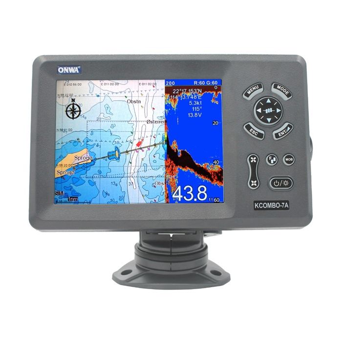
ONWA GPS Chart Plotter with Echo Sounder and Built-in Class B AIS Transponder Fish Finder with Radar - 21.1", Grey (No TDX)


Description
Gain the advantage when using the ONWA GPS Chart Plotter with Echo Sounder and Built-in Class B AIS Transponder Fish Finder with Radar - 21.1", Grey (No TDX). This device will take your catch count to a whole other level, with its built-in radar.
The fish finder features a 21.1 display with a resolution of 800x600 pixels giving you nothing less that the best in display. The device not only looks good but has some amazing features when it comes to the screen like its split screen with GPS chart plotter allowing you to have 2 functions on at a time.
We all want to do a recon on the catches of the day and all the data recorded on the trip, well the ONWA GPS Chart Plotter with Echo Sounder and Built-in Class B AIS Transponder Fish Finder stores all positions of echo history into waypoint memory. When it comes to readings there is no device that gets it more accurate than the ONWA GPS Chart Plotter with Echo Sounder and Built-in Class B AIS Transponder Fish Finder, now this fish finder has exactTrax tracking functionality built into the system, preventing you from getting lost.
Features
- 16 colours according to intensity
- Applies the most advanced digital fish finder technology
- Dual frequency
- Automatic range and gain adjustment depending on usage
- Excellent sea-bed discrimination
- ExactTrax tracking
- AIS messaging
- CPA/TCPA alarm
- AIS track recoding
- AIS targets overlay in potter screen
- Radar overlay
- Saves position of a history echo into waypoint memory
- Split screen or multi screen mode
Specifications
| Physical Supply | |
| Size | 268mm x 365mm x 75mm (H x W x D) |
| Weight | 3.0kg |
| Display | 12" colour TFT dayview LCD, 1024x768 pixels |
| Waterproofing | |
| Display | IPX6 |
| Antenna | IPX6 |
| Temperature Range | |
| Display | -15 degree Celsius to +15 degree Celsius |
| Antenna | -25 degree Celsius to +70 degree Celsius |
| Ethernet Port | Onwa Radar, KM-sonarN, KM-Router, ONENET (Beta Version) |
| Power Supply | 10.5 to 30VDC, current drain 1.5A at 12V |
| Input | (Auto scan Baudrate) GGA, GLL, GSA, GSV, RMC, HDG, HDM, HDT, VTG, ZDA, MTW, VWR, VWT, MWD, VPW, VHW, TLL, TTM, VDO, VDM, GNS, MTA, RMA, DBT, DPT, MWV, BWC, XTE, ZDL, WPL, AAM, APB, BOD, RMB, DSC, MDA, RPM, XDR |
| Output | Baudrate: Selectable 4800, 9600, 19200, 38400, GGA, GLL, RMC, GSA, GSV, AAM, APA, APB, BOD, BWC, BWR, DBT, DPT, HDT, MTW, RMB, TLL, VTG, WPL, XTE, ZDA, ZTG, ZDL, MWD, VPW, VWR, VWT |
| Output For Autopilot | APA, APB, BOD, XTE |
| Ais Characteristics | |
| Frequency | 156.025 |
| Access Scheme | SOTDMA |
| Channel Bandwidth | 25KHz |
| Modulation | GMSK |
| Data Rate | 9600 bps |
| Number Of Ais Transmitter | 1x |
| Number Of Ais Receiver | 2x |
| Ais Channel 1 | CH 87B (161.975 MHz) |
| Ais Channel 2 | CH 88B (162.025 MHz) |
| Tx Power Output | >5 Watt (37 dBm 1.5 dB) |
| Rx Sensitivity | |
| Rx Message Format | AIS Class A and B messages |
| Gps Interface | |
| Ais Data | RS232 input/output, NMEA 0183 V3.01 and V4.11 |
| Gps Input Baudrate | Auto Scan (4800, 9600, 19200 and 38400) |
| Gps Output Baudrate | Selectable among 4800, 9600, 19200 and 38400 |
| Ais Interface | |
| Ais Data | RS232 output VDO, VDM, GGA, GSA, GSV and VTG |
| Ais Output Baudrate | 38,400 |
| Plotter Characteristics | |
| Waypoints/Icons | 12,000 user waypoints with name, symbol, 3 system waypoints: MOB,Start,cursor 10 proximity waypoints |
| Routes | 30 routes waypoint up to 170 points each, plus MOB and Track Navigation or Goto Track modes |
| Tracks | 8,000 points automatic track log 10 saved tracks (up to 8000 track points each) lets you retrace your path in both directions |
| Alarms | XTE, Anchor drag, arrival, speed, voltage, proximity waypoint, Timer and AIS (CPA and TCPA) alarm |
| Drawing | 1000 Drawing Marks 2000 Drawing Lines (40 points each) 1000 Drawing Place Name 8 colours for Drawing |
| Pallete | Normal, Daylight exposed to sunlight, Night in dark environment, NOAA paperchart colours |
| Tides | Built-in Worldwide Tide Data |
| Position Format | Lat/Lon |
| Basemap | Worldwide |
| External Map | Compatible with K-Chart 2.0, K-Chart 3.0, C-Map Max and Navionics+ |
| User Data Storage | Internal backup of user settings or external SD-card |
| Plot Interval | 5 secs to 60 mins or 0.01 to 10nm |
| Plotting Scales | 0.001 to 700nm |
| Ais | 700 targets display |
| Ais Target Tracking | 10 Manually saved tracks (300 points each) |
| Ais Messaging | ONWA AIS to ONWA AIS |
| Perspective View | On/off (available for C-Map only) |
| Celestial | Sunrise/Sunset Moonrise/Moonset |
| Free Shipping | No |
|---|


