In order to use this website you need to accept the use of Cookies , our Privacy Policy , and our Terms and Conditions.
Onwa Kp-39 Compact Gps Chart Plotter - 7-Inch, 800X480, (Non AIS Model)
R5,719.00
SKU
KP39
K-chart
C-map max
Navionics+


Description
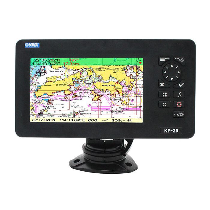
Introducing the Onwa Kp-39 Compact Gps Chart Plotter - 7-Inch, 800X480, (Non AIS Model). The Onwa KP-39 Compact GPS Chart Plotter is a comprehensive navigation tool packed with features tailored for maritime use. With a robust GPS receiver boasting 50 parallel channels, this device accurately computes positions by tracking up to 50 satellites. Its wide array of functionalities includes extensive waypoints, routes, and track navigation capabilities, catering to various navigational needs.
Equipped with a vibrant 7-inch colour TFT LCD, the display showcases crisp and detailed information. Its 800x480 pixel resolution offers clear visuals even in bright daylight conditions, aided by multiple display modes for different lighting environments such as daylight, nighttime, and NOAA paper chart colours.
With its compact design, waterproofing (IP66 rating for both display and antenna units), and wide temperature tolerance, the Onwa KP-39 is suitable for marine environments. Its intuitive interface, celestial information display, tide tables, and multiple display modes make it a versatile and user-friendly tool for navigational needs on the water.
Please Note: This is the non AIS Model and does not include AIS
Features
- K-chart
- C-map max
- Navionics+
- Plotter
- Navigation data
- Compass
- Highway
- Wind
- Satelite
- Multi display modes
- Proximity waypoint alarm
- Perspective view
- Different colour palettes
- Sd card system update
- Tide table
- Celestial
- Display AIS info
- Ip66
- Nmea0183
Specifications
| Plotter Characteristics | |
| Waypoints/Icons | 12,000 user waypoints with name, symbol, 3 system waypoints: MOB, Start,cursor |
| 10 proximity waypoints | |
| Routes | 30 routes waypoint up to 170 points each, plus MOB and Track Navigation or Goto Track modes |
| Tracks | 8,000 points automatic track log, 10 saved tracks (up to 8000 track points each) lets you retrace your path in both directions |
| Alarms | XTE, Anchor drag, arrival, speed, voltage, proximity waypoint, Timer and AIS (CPA and TCPA) alarm |
| Drawing | 1000 Drawing Marks, 2000 Drawing Lines (40 points each), 1000 Drawing Place Name, 8 colours for Drawing |
| Pallete | Normal |
| Daylight exposed to sunlight | |
| Night in dark environment | |
| NOAA paperchart colours | |
| Tides | Built-in Worldwide Tide Data |
| Position Format | Lat/Lon |
| Basemap | Worldwide |
| External Map | Compatible with K-Chart 2.0, K-Chart 3.0, C-Map Max and Navionics+ |
| User Data Storage | Internal backup of user settings or external SD-card |
| Plot Interval | 5 secs to 60 mins or 0.01 to 10nm |
| Plotting Scales | 0.001 to 700nm |
| Perspective View | On/off (available for C-Map only) |
| Celestial | Sunrise/Sunset Moonrise/Moonset |
| Gps Receiver Characteristics | |
| Receiver | 50 parallel channel GNSS receiver continuously tracks and uses up to 50 satellites to compute and update your position |
| Acquisition Time | Cold start: 29 seconds |
| Hot start: 1 second | |
| Update Rate | 1 second or 0.1 second selectable |
| Accuracy | Position:3 meters(95%) without S/A |
| Velocity: 0.1 meter/sec without S/A | |
| Sbas | Supported |
| Qzss | Supported |
| Satellite System | Choice of 4 GNSS: GPS, Beidou, GLONASS and Galileo |
| Dynamics | Altitude: 18,000 m |
| Velocity: 515 m/s | |
| Datum | WGS 84 & user defined |
| Antenna | GPS Patch Antenna |
| Gps Interface | |
| Gsp Data | RS232 input/output, NMEA 0183 V3.01 and V4.11 |
| Gps Input Baudrate | Auto Scan (4800, 9600, 19200 and 38400) |
| Gps Output Baudrate | Selectable among 4800, 9600, 19200 and 38400 |
| Ais Interface | |
| Ais Data | RS232 output VDO, VDM, GGA, GSA, GSV and VTG |
| Ais Input Baudrate | 38,400 from GPS Input Port |
| Nmea Sentence Supported | |
| Input | (Auto scan Baudrate) |
| GGA, GLL, GSA, GSV, RMC, HDG, HDM, HDT | |
| VTG, ZDA, MTW, VWR, VWT, MWD, VPW, VHW | |
| TLL, TTM, VDO, VDM, GNS, MTA | |
| RMA, DBT, DPT, MWV, BWC, XTE, ZDL, WPL, AAM | |
| APB, BOD, RMB, DSC, MDA, RPM, XDR | |
| Output | Baudrate: Selectable 4800, 9600, 19200, 38400 |
| GGA, GLL, RMC, GSA, GSV, AAM, APA | |
| APB, BOD, BWC, BWR, DBT, DPT, HDT | |
| MTW, RMB, TLL, VTG, WPL, XTE, ZDA | |
| ZTG, ZDL, MWD, VPW, VWR, VWT | |
| OUTPUT for Autopilot | |
| APA, APB, BOD, XTE | |
| Power Supply | 10.5 to 30VDC, current drain 1.0A at 12V |
| Physical | |
| Size | 187mm(H)X250.1mm(W)X88mm(D) |
| Weight | 0.8 kg |
| Display | 7-inch Color TFT dayview LCD, 800x480 pixels |
| Waterproofing | Display unit (Front Panel): IP66 |
| Antenna unit: IP66 | |
| Temperature Range | Display unit: -15 to +55 |
| Antenna unit: -25 to +70 |
| Free Shipping | No |
|---|
Write Your Own Review
Customer Questions